Last Ape Standing Dispatch #3: Cape Town and Beyond
This post was originally published on November 15, 2019 on a previous version of ChipWalter.com.
March 3, 2013
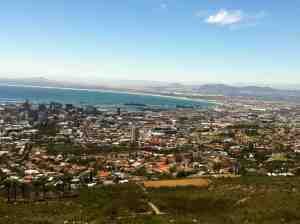
Cape Town from Table Mountain. Up to 5 million people now live here flooding in from all over Africa.
I packed up my bags in my very nice central Cape Town hotel room, threw them in my rented VW and began to navigate my way, warily, and on the wrong side of the road (to me at least), out of the city. A few gears were crunched. My rental was a 5 speed, and I was shifting with my left hand. I am NOT left handed. Cape Town is big, populated by roughly 5 million people, though it’s difficult to say precisely how many really live here because a significant number of its denizens are illegal immigrants who have flocked in from less stable regions throughout Africa. Let’s just say there were lots of buildings. Lots of cars. Lots of people in the cars and lots of intersecting highways as I made my way east.
When I had arrived Friday night, Howard, the very gentlemanly cab driver who found me at the airport, pointed out the shanty towns that had been set up to house the thousands of people pouring into the city. I was reminded of the pictures of corrugated metal affairs I had seen from the Dust Bowl era, shacks that had been thrown together out of anything handy. These were, Howard told me, not to be confused with the old “townships” that were home to non-whites when apartheid was at its height. I saw those later in the daylight, to the east, and if anything they were sometimes worse: small boxes of cement or stucco with crooked roofs no larger than an average hotel room. Except these were supposed to house whole families, and they did. Apartheid as a policy was now supposed to be more than 20 years passed, but old ways die hard, and for many, life hasn’t yet changed materially.
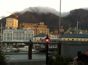
Clouds roll over Table Mountain in Capetown the night before my departure to the east. To me it looked like an animal with an immense hand creeping over the mountain’s edge.
I managed to get onto the N-2 Highway headed east without smashing directly into any oncoming cars. Clutching and shifting never became fully normal, but I improved with each round of crashing gears. I’m pretty sure everyone in Cape Town was happy to see me get on the freeway where at least there was no two-way traffic.
Given the size of it population it takes a good half hour of steady out-of-Cape Town driving to get beyond the feeling you’re in a city. Soon the shanties and township buildings gave way to flatlands with mountains rising up before me, reddish and jagged, eroded but still impressive.
My directions, from Karen van Neikerk of the scientific team I would be joining for this assignment told me to make my way to an out post called Potberg on the edge of the De Hoop Nature Reserve. That would be 3 hours east of Cape Town, traveling first on the big six lane highway (the N-2), then off into a town called Napier where I would follow a two lane to a place called Braedesdorp, turn onto a back country road at a particular gas station and then drive 60 kilometers (about 36 miles) on a two lane gravel road following this sign and that until, as she put it, “the road ends.”
Somehow, driving to the the end of the road seemed right for this assignment. It was a long way from Cape Town, and a very long way from Pittsburgh, in so many ways.
I followed the directions, and with each mile shed a little more civilization, rising out of the coastal plains, through the high mountain pass. The views were breathtaking. The other side reminded me of the foothills of Wyoming or Montana, even some parts of Colorado around Boulder before you get into the Flatirons. Not shear cliffs, but mountains and wide expanses of undulating prairie eventually rising up the mountains’ feet. The scale of the land made the sky feel huge. Space was not in short supply. I was now well out of the traffic. Cars grew rare. Napier was no more than a cross-road, and beyond that there were far more sheep and cattle than people. Braedesdorp was a charming, a little village, with clean-lined, brightly colored buildings, all of it exceedingly ordered. I had the impression that it had been transported whole from the Netherlands and plopped on the sunny South Africa plateau, which, in a way it had because Dutch settlers many years before had created it to service the huge farms and cattle and sheep ranches that surrounded it.
Soon I was on the gravel road, which made a perfect and very long washboard. I rattled along for another hour (my VW could go only so fast on this surface), sending up plumes of dust into the faces of the grazing sheep. An occasional car or truck passed from the other direction, reminding me periodically to get back on my side of the road. Here and there a few farm buildings rose into view and then slid by.
After making only one wrong turn, I found myself on a very small one lane, bumping along, until after perhaps another mile, I came, at last, to the “end of the road.”
Next: I meet the scientific crew, and get some lessons on how to handle baboons, puff adders, cobras, riptides and the occasional leopard.